Salar de Uyuni is located at 20.1338° S, 67.4891° W (Google).
With a latitude of 20.1338° S Salar de Uyuni is relatively close to the
Equator. Salar de Uyuni, the largest salt flat in the world, is atop a large
plateau called the Altiplano. It was created when a part of a giant prehistoric
lake, Lake Minchin, dried up. This giant lake is now split into four separate
lakes. This salt flat is completely surrounded by mountains with no drainage
point (NASA).
| A topographic map of the Salar de Uyuni, Bolivia (Google Maps). |
Why the Salar de Uyuni is dry could be because the region
where Salar de Uyuni sits is directly affected by the Trade Winds, more
specifically the Southeast Trade Winds. The Trade Winds are winds that go from
the Equator to about 30° latitude both North and South. These are very dry and
warm winds that hold a lot of water. However, with the salt flat being surrounded
by the mountains, the moisture is stopped by this obstacle. The Trade Winds
tend to make the windward side of geographic locations wet, with the leeward
side being dry.
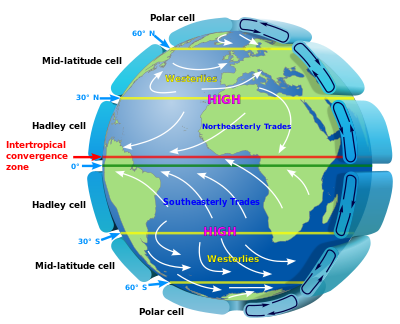 | ||
| Diagram of winds and Hadley cells. Near the equator you can see the ITCZ where the NE and SE Trade Winds meet (Wikipedia). |
With the Salar de Uyuni being the largest salt flat in the
world, the salt reflects light and appears to be the color white. It is so
large and unchanging that it is often used for satellite testing. NASA states
that it is often used to calibrate satellites (NASA).
| Satellite image of Salar de Uyuni, Bolivia (Google). |
The average maximum temperature of Salar de Uyuni throughout
the year is in between 13° C to 21° C (whatstheweatherlike.org). With the Salar
de Uyuni being approximately - 20° from the Equator, this temperature is a bit lower
than I expected, with the average temperature at the Equator at 30° C. This
could be because of Salar de Uyuni’s altitude with it being at 3,656 meters
above sea-level (Encyclopedia Britannica).
References
NASA Earth Observatory. (June 4, 2014). http://earthobservatory.nasa.gov/IOTD/view.php?id=84853.
Retrieved March 3, 2017.
NASA Earth Observatory. (September 20, 2012). http://earthobservatory.nasa.gov/IOTD/view.php?id=79347.
Retrieved March 3, 2017.
What’s the weather like .org. Climate of Salar de Uyuni, Bolivia. http://www.whatstheweatherlike.org/bolivia/salar-de-uyuni.htm.
Retrieved
March 1, 2017.
Encyclopedia Britannica. "Uyuni Salt Flat". https://www.britannica.com/place/Uyuni-Salt-Flat. Retrieved
March 1, 2017.
Google. Topographic
Map of Salar de Uyuni. https://www.google.com/#q=salar+de+uyuni+coordinates&*.
Retrieved March 3, 2017.
Wikipedia. Trade
Winds. https://en.wikipedia.org/wiki/Trade_winds.
Retrieved March 4, 2017.
Google. Satellite
Image of Salar de Uyuni. https://www.google.com/search?q=satellite+images+of+salar+de+uyuni&spell=1&sa=X&ved=0ahUKEwjU7PCZsMHSAhVE2GMKHZsLDjoQvwUIGSgA.
Retrieved March 4, 2017.